Mapping the Vilna Page
 View full map
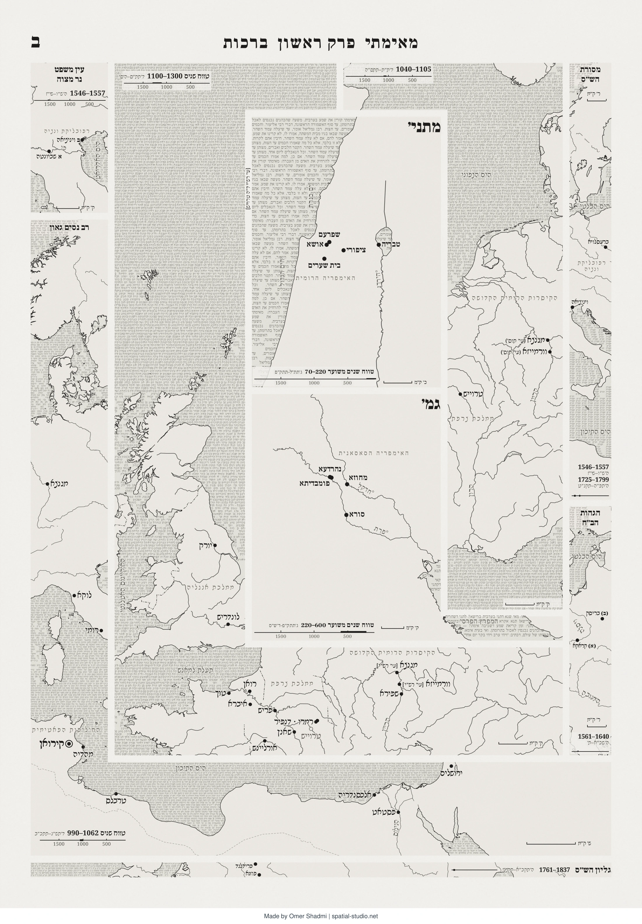
The map shows the spatial background of the different authors in the layout of the opening folio of the Vilna edition of the Babylonian Talmud (Berachot 2a). Each map replaces the original text and shows the corresponding authors’ historical spatial background. Each map keeps the shape and position of each commentary, uses the box’s own script for all of its lettering, and carries a timeline of the period in which the text was written. Through the map the Vilna folio becomes a journey into 1600 years of Jewish history and geography.
How this map was created
Mapping the Vilna Page
The Spatial Studio – Omer Shadmi
This file was created manually in retrospect
General information
The map shows the spatial background of the different authors in the layout of the opening folio of the Vilna edition of the Babylonian Talmud (Berachot 2a). Each map replaces the original text and shows the corresponding authors’ historical spatial background. Each map keeps the shape and position of each commentary, uses the box’s own script for all of its lettering, and carries a timeline of the period in which the text was written. Through the map the Vilna folio becomes a journey into 1600 years of Jewish history and geography.
Map title | Mapping the Vilna Page |
Author | Omer Shadmi |
Publication date / version | October 20, 2026 / 1 |
Geographic coverage | Various |
CRS | Source data WGS84 (EPSG:4326); maps drawn in a custom spherical Lambert azimuthal equal-area projection (R = 6371 km), centered separately on each map (see table); output in page pixels. |
Dimensions | 1123 × 1587 px page (A3 portrait) |
Map file | Berakhot_2a_as_maps_A3 / [URL] |
Software | Claude, models Opus 5.5 and Sonnet 5.5 |
Documentation date / method | October 19, 2026 / Retrospective |
Permanent link | https://spatial-studio.net/maps/mapping-the-vilna-page/ |
Suggested citation
Omer Shadmi. (2026). Mapping the Vilna Page [Map]. Spatial Studio. https://spatial-studio.net/maps/mapping-the-vilna-page/
How this map was created
This table was created manually based on a report produced by Claude and a review of prompt history.
# | Operation |
1 | I Uploaded to Claude an image of Berachot 2a Vilna page with boxes tracing each page section. Typed the following prompt: “Discussing an idea: create a vilna page of berachot 1b as maps showing where each part was created. In the file attached you see the boxes of each part for reference (not a guideline). Each map will show the places in the same font as the text. What’s outside the box at the top except for מסורת הש"ס remains as title, ignore the bottom. Each map also includes a timeline and name. Suggest nice ideas and raise difficulties” |
2 | Claude suggested several more ideas, some were good, some irrelevant, some impossible. After a conversation and several rounds of decisions it produced a first draft. |
3 | Stages 3-5 were done in parallel in about 15 rounds of review in chat: fixing maps frames to match the page layout, setting fonts to match the Vilna folio, deciding maps titles, deciding map extents, adding the original text in seas, choosing color and texture, fixing places with wrong locations, adjusting wrong and displaced labels, positioning time bar and scale bar. |
4 | Asked Claude to add historical political boundaries. Result was poor and I asked it to remove them. Labels for political entities kept, Claude’s initial labels were mostly right but required review and some changes. |
5 | Asked Claude to specify its data sources (see data source table) |
6 | I consulted the following book to verify several locations and map extents: Jacob Z. Mayer, and Ishay Rosen-Zvi. The Talmud: A History of Learning. (Magness, 2025) [in Hebrew] |
7 | Final review before publishing protocol. Changes: remove political boundaries traces in several maps; fixing displaced wrong and distorted labels; fixing north arrows style and position; adding data sources; writing this file |
Data sources
This table was created based on a report by Claude, verified and edited by the author.
Places
Map | Places |
Mishnah | Pleiades (Usha, Beit She’arim, Sepphoris, Tiberias); OpenStreetMap (Shefar’am) |
Gemara | Pleiades (Anbar for Nehardea, Veh Ardashir for Mahoza); OpenStreetMap (Fallujah for Pumbedita, al-Hirah for Sura); approximate for Sura and Pumbedita. Corrected by Omer. |
Rashi | OpenStreetMap. |
Tosafot | OpenStreetMap, checked; scholars from the Jewish Encyclopedia (1906), Encyclopaedia Judaica, a 2023 study in Revue des Études Juives, VIAF, the Posen Library and the Jewish Historical Society of England |
Rav Nissim Gaon | Claude’s training data |
Ein Mishpat | Claude’s training data |
Masoret HaShas | Claude’s training data |
Hagahot HaBach | Claude’s training data |
Gilyon HaShas | Claude’s training data |
Other data
Dataset | Publisher |
Base map (coast, lakes, rivers) | naturalearthdata.com |
Hebrew texts | Sefaria |
Fonts: Frank Ruhl Libre, Noto Rashi Hebrew | Google Fonts |
Lambert azimuthal equal-area projection centers by map
Map | Center longitude (° E) | Center latitude (° N) | Center on page (px) |
Mishnah | 35.3 | 32.78 | 606, 430 |
Gemara | 44.487 | 31.890 | 606, 900 |
Rashi | 6.2 | 49.2 | 884, 640 |
Tosafot | 4.2 | 49.0 | 549, 1235 |
Rav Nissim Gaon | 10.1 | 35.68 | 121, 1300 |
Ein Mishpat | 11.6 | 45.05 | 121, 262 |
Masoret HaShas | 14.7 | 48.0 | 1032, 490 |
Hagahot HaBach | 21.8 | 51.1 | 1032, 1100 |
Gilyon HaShas | 16.6 | 52.9 | 450, 1520 |
License
This work is licensed under the Creative Commons Attribution 4.0 International License (CC BY 4.0, https://creativecommons.org/licenses/by/4.0/). It may be used, shared and adapted freely, including for commercial purposes, provided that appropriate credit is given.
Version history
None
Cite this map
Shadmi, Omer. (2026). Mapping the Vilna Page [Map]. The Spatial Studio. https://spatial-studio.net/maps/mapping-the-vilna-page/
License
This work is licensed under the Creative Commons Attribution 4.0 International License (CC BY 4.0, https://creativecommons.org/licenses/by/4.0/). It may be used, shared and adapted freely, including for commercial purposes, provided that appropriate credit is given.
Permanent link: https://spatial-studio.net/maps/mapping-the-vilna-page/