The World in the Scholarship of Eyal Ben-Eliyahu
 View full map
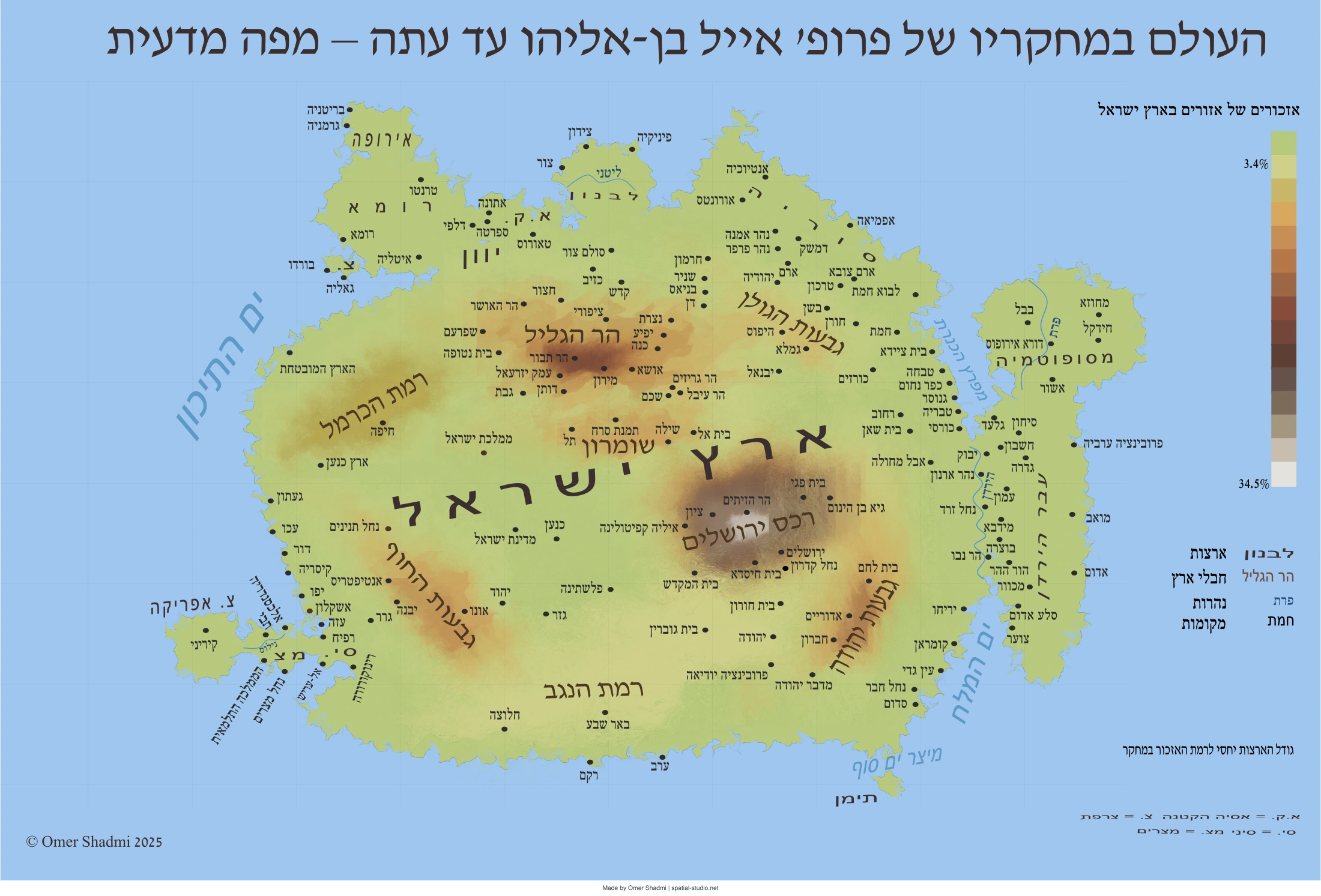
This map shows which parts of the world feature most prominently in Eyal Ben-Eliyahu’s published scholarship. Place names and geographical subjects were identified in his books and other publications, assigned numerical values, and grouped by region. The geographical shapes were then redrawn to make the resulting pattern visible. It is a map of research emphasis, not a conventional map of actual distances or land areas.
How this map was created
The World in the Scholarship of Eyal Ben-Eliyahu
How this map was created — research method and provenance record
Retrospective documentation of the research process, calculations and cartographic design. Prepared and reviewed 29 October 2026.
1. General
Field | Record |
Map title (English) | The World in the Scholarship of Eyal Ben-Eliyahu |
Title on map (Hebrew) | העולם במחקריו של פרופ׳ אייל בן־אליהו עד עתה – מפה מדעית |
Cartographer | Omer Shadmi | The Spatial Studio | spatial-studio.net |
Map date and format | November 2025; PDF; 60 × 40 cm; landscape |
Map file | eyal 60X40.pdf https://spatial-studio.net/maps/eyal-ben-eliyahu/ |
Map design software | Inkscape 1.2.2 |
Documentation | Retrospectively prepared with ChatGPT (GPT-6); reviewed and edited by Omer Shadmi, 29 October 2026 |
Permanent link | https://spatial-studio.net/maps/eyal-ben-eliyahu/ |
This map shows which parts of the world feature most prominently in Eyal Ben-Eliyahu’s published scholarship. Place names and geographical subjects were identified in his books and other publications, assigned numerical values, and grouped by region. The geographical shapes were then redrawn to make the resulting pattern visible. It is a map of research emphasis, not a conventional map of actual distances or land areas.
3. How this map was created
3.1 Place-name extraction from Ben-Eliyahu’s research
Place names were extracted from the scholarship of Ben-Eliyahu. The corpus comprises two books and sixteen other publications (journal articles, chapters and collaborative contributions), published between 2000 and 2025. The full publication list is reproduced in section 7. Place names were identified manually from the indexes of the two books and extracted manually from the articles
3.2 Geographical assessment of other publications
Place names and geographical subjects in the shorter publications were extracted manually. An individual recorded occurrence counted as one unit. Places constituting a principal article subject received additional weight, so the resulting value could exceed the number of literal mentions.
3.3 Geographical classification
Every geographical entry was classified manually into a regional category. Named sites and areas were assigned to geographical groupings, including regions of the Land of Israel, neighbouring territories, places elsewhere in the Mediterranean and wider world, and water bodies. The categories represent interpretive research decisions; names that refer to broad or historically variable territories are not equivalent to pinpoint locations.
3.4 Aggregation and percentages
The recorded values were summed by geographical category. Percentages for broad land areas were calculated relative to the subtotal of 2,607 non-water, geographically allocated units (with the 14-unit “Asia” category excluded from that particular subtotal). Percentages for individual regions within the Land of Israel used a denominator of 1,671 units, including 293 units classified only as “Land of Israel — general.” The examples below retain this denominator so that the legend can be interpreted consistently.
3.5 Cartographic transformation
The geographical outlines were redrawn and distorted manually in Inkscape. Relative area and a graduated colour scheme were used to convey the research distribution. The area distortion was a design interpretation rather than the output of a recorded algorithm assigning a calculated polygon size to each geographical unit.
Within the Land of Israel, the named regions are depicted with graduated colour and elevation-like shading to convey their relative prominence in the analysis, rather than actual measured elevation.
5. Quantitative summary and how to read it
Table 1. Recorded numerical units by publication or identifiable publication working block
Publication / identifiable working allocation | Weighted units |
Between Borders (2013) — book | 1,143 |
Identity and Territory (2019) — book | 531 |
Uzziah’s tomb / Mount of Olives — working block | 70 |
Edom / Red Rock — working block | 70 |
Bethphage — working block | 70 |
Mount of Olives — first recorded block | 70 |
Canaanites in the Land of Israel — working block | 70 |
Mount of Olives — second recorded block | 70 |
Remus and Romulus in Rome — working block | 70 |
Building a new Temple — working block | 70 |
Travels of the rabbis — working block | 75 |
ALMA Digital Atlas — working block | 54 |
JQR-labelled publication — working block | 70 |
Rabbinic polemic against sanctification — working block | 70 |
Cities surrounded by a wall — working block | 70 |
Mediterranean viticulture — working block | 70 |
Josephus’s Lands — working block | 66 |
Total | 2,709 |
Table 2. Recorded values by broad geographical area (“country” category)
Area or territorial category | Weighted units | Share of 2,607 |
Land of Israel | 1,671 | 64.1% |
Syria | 120 | 4.6% |
Lebanon | 108 | 4.1% |
Transjordan | 320 | 12.3% |
Egypt | 25 | 1.0% |
Greece | 23 | 0.9% |
Rome | 153 | 5.9% |
Babylonia / Mesopotamia | 69 | 2.6% |
Asia Minor | 12 | 0.5% |
France | 12 | 0.5% |
Sinai | 22 | 0.8% |
North Africa | 33 | 1.3% |
Yemen | 5 | 0.2% |
Northern Europe | 34 | 1.3% |
Allocated land areas — total | 2,607 | 100% |
These categories include historical and broad geographical territories, not only present-day countries. The 88 water-related units and the 14 units classified as “Asia” are outside this subtotal.
Table 3. Recorded values by region within the Land of Israel
Region | Weighted units | Share of 1,671 |
Jerusalem | 577 | 34.5% |
Galilee | 322 | 19.3% |
Judea | 183 | 11.0% |
Samaria | 96 | 5.7% |
Coastal Plain | 120 | 7.2% |
Negev | 9 | 0.5% |
Carmel | 14 | 0.8% |
Golan | 57 | 3.4% |
Land of Israel — general / unallocated | 293 | 17.5% |
Land of Israel — total | 1,671 | 100% |
The “Land of Israel — general” entry includes values not assigned to any one region and is included in the denominator for every percentage.
The 34.5% and 3.4% figures correspond to the endpoints of the regional colour legend. They include broadly classified “Land of Israel” units in their denominator, even though those units cannot be placed in one specific subregion.
6. Publications included in the analysis
The bibliography below identifies the two books and the other publications represented in the research corpus.
Books
בן־אליהו, אייל. בין גבולות: תחומי ארץ־ישראל בתודעה היהודית בימי הבית השני ובתקופת המשנה והתלמוד. ירושלים: יד יצחק בן־צבי, 2013.
Ben-Eliyahu, Eyal. Identity and Territory: Jewish Perceptions of Space in Antiquity. S. Mark Taper Foundation Imprint in Jewish Studies. University of California Press, 2019.
Articles, chapters and collaborative works
בן־אליהו, אייל. “למקומו של הכפר בית פגי.” על אתר (2000): 51–62.
בן־אליהו, אייל. “למקורו של ציון עוזיהו.” קתדרה 98 (2000): 157–158.
בן־אליהו, אייל. “להקים בנין חדש? הרב קוק, הרב הירשנזון והרצל על בניין המקדש וחידוש הקורבנות.” קתדרה 128 (2008): 101–112.
בן־אליהו, אייל. “מה לבת בבל בסלע אדום?” קתדרה 133 (2009): 5–12.
Ben-Eliyahu, Eyal. “The Rabbinic Polemic against Sanctification of Sites.” Journal for the Study of Judaism 40, no. 2 (2009): 260–280.
בן־אליהו, אייל. “מ׳יהודה׳ ל׳ישראל׳ – טריטוריה וזהות לאומית.” ציון 75, no. 2 (2010): 127–151.
Ben-Eliyahu, Eyal. “The Rabbinic Perception of the Presence of the Canaanites in the Land of Israel.” In The Gift of the Land and the Fate of the Canaanites in Jewish Thought, edited by Katell Berthelot, Joseph E. David, and Marc Hirshman. Oxford University Press, 2014.
Ben-Eliyahu, Eyal. “On That Day, His Feet Will Stand on the Mount of Olives: The Mount of Olives and Its Hero between Jews, Christians, and Muslims.” Jewish History 30, nos. 1–2 (2016): 29–42.
Ben-Eliyahu, Eyal. “Cities Surrounded by a Wall from the Time of Joshua Son of Nun as a Rabbinic Response to the Roman Pomerium.” Jewish Quarterly Review 106, no. 1 (2016): 1–20.
Ben-Eliyahu, Eyal. “Josephus’s Lands: Mining the Evolution in the Depiction of the Land of Israel in the Works of Josephus.” Journal for the Study of the Pseudepigrapha 26, no. 4 (2017): 275–304.
Ben-Eliyahu, Eyal. “The Travels of the Rabbis and the Rabbinic Horizons of the Inhabited World.” In Maps and Travel in the Middle Ages and the Early Modern Period: Knowledge, Imagination, and Visual Culture. De Gruyter Mouton, 2019.
Yoskovich, Avraham, Or Rappel-Kroyzer, Yanir Marmor, Sarel Levi, and Eyal Ben-Eliyahu. “ALMA Digital Atlas of the Ancient Jewish World: An Introductory Essay.” Jerusalem Journal of Archaeology 5 (2023): 58–75.
Ben-Eliyahu, Eyal. “Where Were the Two Huts of Remus and Romulus in Rome?” In Cultural Encounters in Late Antiquity and the Middle Ages, vol. 40, edited by Brouria Bitton-Ashkelony and Martin Goodman. Brepols, 2023.
Ben-Eliyahu, Eyal. “תפיסת העולם של היהודים בעת העתיקה” [in Hebrew]. In A Vision of the Days: Studies in Early Jewish History and Historiography (2024): 684–696.
Ben-Eliyahu, Eyal. “Jewish Global Geography: From the Second Temple Period to Rabbinic Literature.” Jewish Studies Quarterly 31, no. 4 (2024): 305–322.
Miller, Shulamit, Guy Bar-Oz, Eyal Ben-Eliyahu, and Gil Gambash. “Mediterranean Viticulture in Late Antique Palestine.” Journal of Interdisciplinary History 56, no. 1 (2025): 43–79.
8. Citation, licence and attribution
How to cite the map. Shadmi, Omer. The World in the Scholarship of Eyal Ben-Eliyahu [map]. The Spatial Studio, 2025. 60 × 40 cm. https://spatial-studio.net
Permission to reuse. The map and this documentation are free to use, share and reproduce, provided that proper credit is given to Omer Shadmi, The Spatial Studio (2025), spatial-studio.net. This permission concerns the original contributions by the cartographer; separately owned third-party material, if any, remains subject to its own rights.
Suggested credit line. © Omer Shadmi 2025 | The Spatial Studio | spatial-studio.net. Reproduced with attribution.
Cite this map
Shadmi, Omer. (2025). The World in the Scholarship of Eyal Ben-Eliyahu [Map]. The Spatial Studio. https://spatial-studio.net/maps/eyal-ben-eliyahu/
License
The map and this documentation are free to use, share and reproduce, provided that proper credit is given to Omer Shadmi, The Spatial Studio (2025), spatial-studio.net. This permission concerns the original contributions by the cartographer; separately owned third-party material, if any, remains subject to its own rights.
Permanent link: https://spatial-studio.net/maps/eyal-ben-eliyahu/