Estimated Wetland Extent during the Late Holocene
 View full map
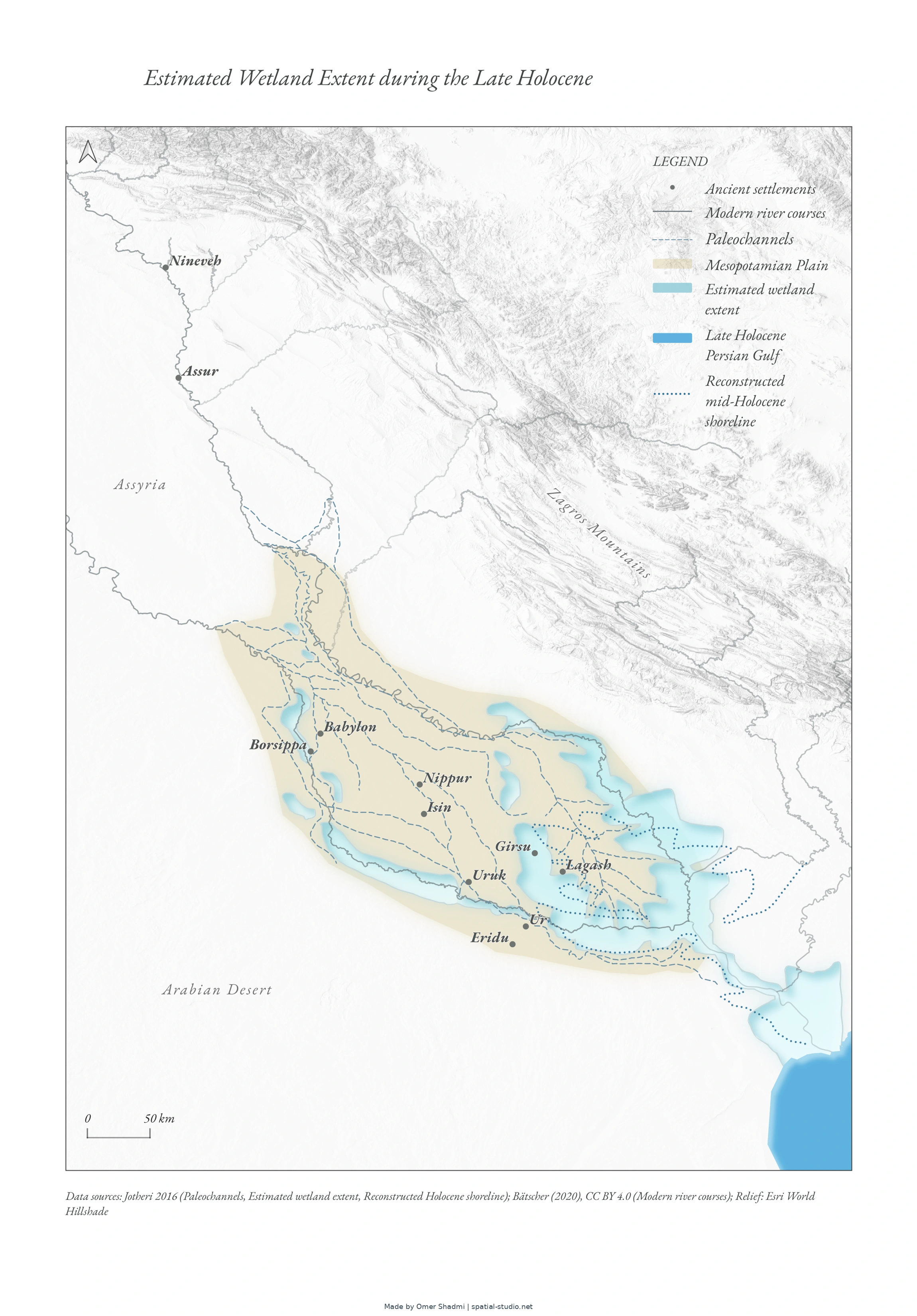
The map shows the estimate extent of wetlands in the Mesopotamian plain during the Late Holocene. For the dissertation “Lost in the Marshes: On the Ancient Mesopotamian Conception of Wetlands,” Hebrew University
How this map was created
Estimated Wetland Extent during the Late Holocene
The Spatial Studio – Omer Shadmi
This file was created manually in retrospect
General information
The map shows the estimate extent of wetlands in the Mesopotamian plain during the Late Holocene. For the dissertation “Lost in the Marshes: On the Ancient Mesopotamian Conception of Wetlands,” Hebrew University
Map title | Estimated Wetland Extent during the Late Holocene |
Author | Omer Shadmi |
Owner | Yael Leokumovich |
version | 1 |
Geographic coverage | Mesopotamian plain and adjacent regions, including the Persian Gulf |
CRS | WGS 84 (EPSG:4326) |
Dimensions | A4 portrait (210 × 297 mm); |
Map file | A4 Dissertation1.pdf |
Software | QGIS 3.40.14-Bratislava |
Documentation date / method | October 29, 2026/ Retrospective |
Permanent link | https://spatial-studio.net/maps/estimated-wetland-extent/ |
How to cite this map
Consult owner
How this map was created
# | Operation |
1 | Jotheri maps manually georeferenced in QGIS. Ancient shoreline, Paleochannels, and wetlands traced manually |
2 | Ancient settlements points marked. |
3 | Modern river-course data added from RIMES layer. Some attributes removed. |
4 | Mesopotamian plain layer manually marked around the Mesopotamian irrigated area. |
5 | Design of all elements made manually except for what’s in AI operation table. |
AI operations
# | Operation | Model | Input | Request | Output |
1 | Symbol change – mid-Holocene shoreline. Data lock instated. | Claude Opus 5.5 | Full QGIS project files | Suggest symbols and apply human choice to QGIS project | Updated full QGIS project. |
2 | Layout production | Claude Opus 5.5 | Full QGIS project files | Create an A4 layout | Updated full QGIS project |
Data sources
Layers
Map | Source |
Paleochannels; estimated wetland extent; | Jotheri, Jaafar (2016) Holocene avulsion history of the Euphrates and Tigris Rivers in the Mesopotamian Floodplain, Durham theses, Durham University. Figure 5.2 |
Reconstructed mid- Holocene shoreline | Jotheri, Jaafar (2016) Holocene avulsion history of the Euphrates and Tigris Rivers in the Mesopotamian Floodplain, Durham theses, Durham University. Figure 5.1 |
Ancient settlement coordinates | Wikidata |
Other data
Dataset | Publisher |
Modern river courses | RIMES. Bätscher (2020), CC BY 4.0 |
World Hillshade (relief) | Esri |
License
Consult Owner
Version history
None
Cite this map
Shadmi, Omer. (n.d.). Estimated Wetland Extent during the Late Holocene [Map]. The Spatial Studio. https://spatial-studio.net/maps/estimated-wetland-extent/
The documentation requests consultation with the owner, Yael Leokumovich, about citation and reuse.
License
Consult Owner
Permanent link: https://spatial-studio.net/maps/estimated-wetland-extent/